The roads of Kumaon — six districts, five itineraries and route maps
Start at Kathgodam, Ramnagar or Tanakpur. Five trips of three to nine days give you the order of stops, overnight bases and time to spare across Kumaon’s six districts.
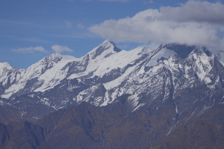
Picture the light fading at Birthi Falls with the climb to Munsyari still ahead. The decision that matters was made last night. Starting the morning in Chaukori leaves room for a stop at the falls. Starting in the plains makes the drive itself the day’s event. Choose your overnight bases first, then fill in the places between them.
Which gateway fits your trip?
Kathgodam works for Bhimtal, Nainital and the ascent to Almora. Sleep near Ramnagar for Corbett, and use Tanakpur for Champawat and Lohaghat. Pantnagar airport is in Udham Singh Nagar. The plains are part of Kumaon too. Drona Sagar at Kashipur is on the western side, while Nanakmatta Sahib and Nanak Sagar reservoir lie to the east. Combining both with a safari would add a long journey across the plains.
Kumaon Division · Udham Singh Nagar district guide · Airports Authority of India, Pantnagar
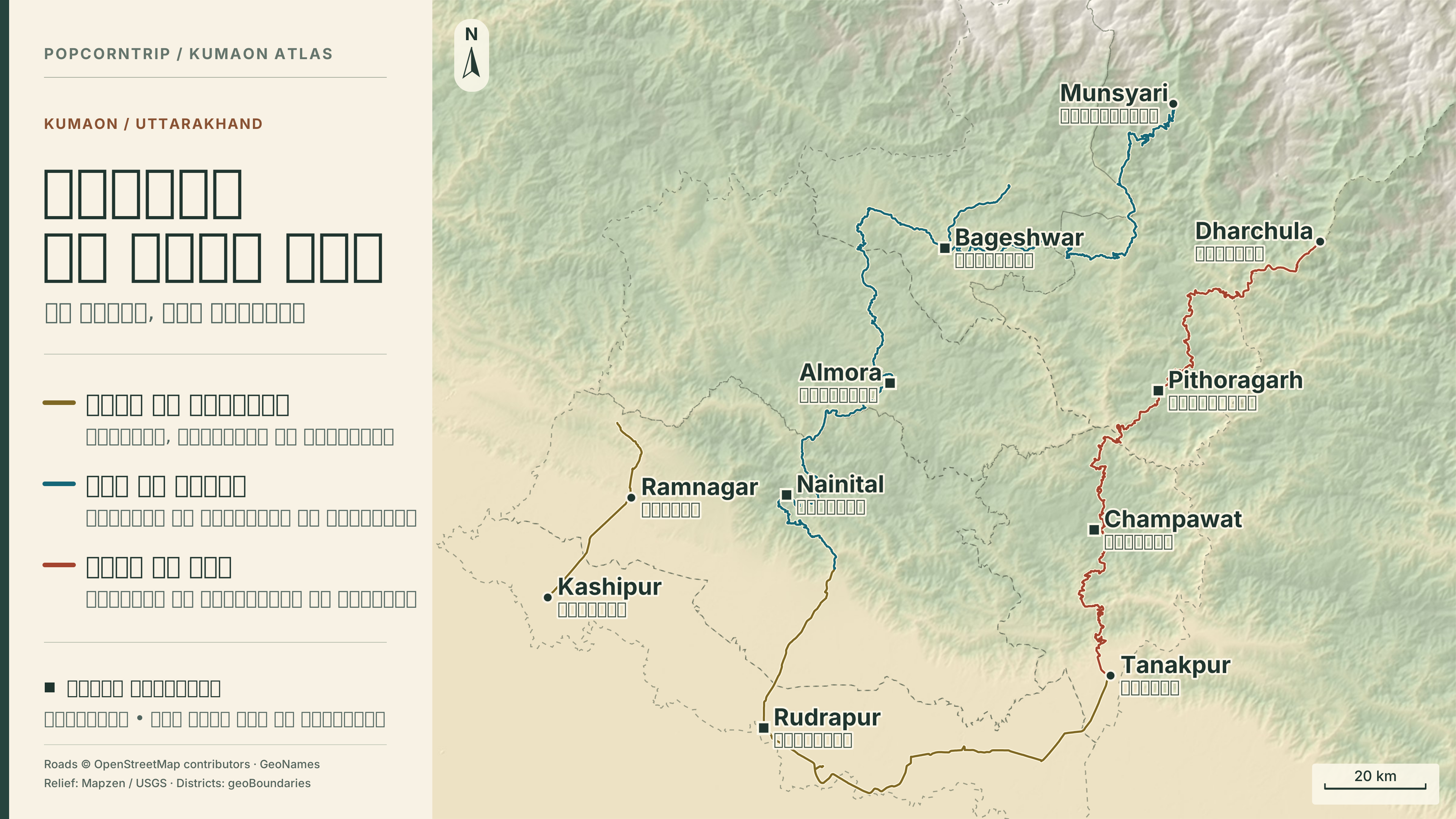
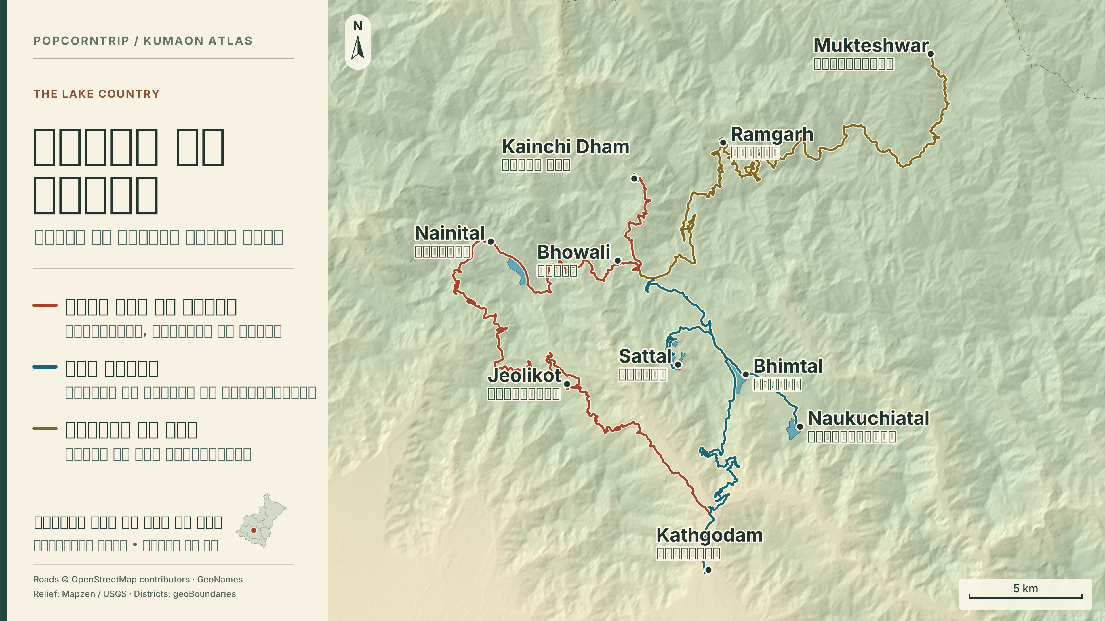
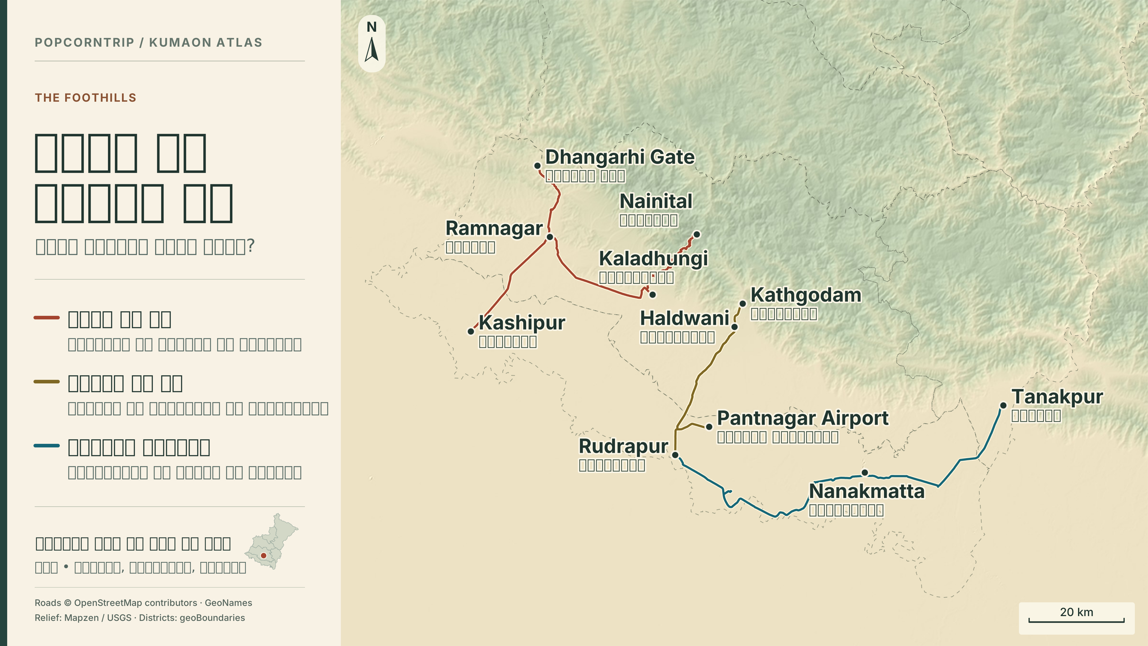
North is up on each map. Place labels show English above Hindi. Tap any map to open it at full size. Follow the coloured routes to understand the order of stops. Confirm the open road and junctions on the day you drive.
Three days by the lakes
Keep both nights at Bhimtal. With your bags unpacked, you can give one day to a quiet shore and the next to the streets of Nainital.
- Day 1 Travel from Kathgodam to Bhimtal. Settle in and walk the lakeshore. Add Naukuchiatal only if you have daylight. Sleep in Bhimtal.
- Day 2 Go via Bhowali to Nainital. Walk from Tallital to Mallital by the lake and pause near Naina Devi temple. Return to Bhimtal for the night.
- Day 3 Spend the morning at Sattal before descending to Kathgodam. With an early train, move Sattal to day one or skip it.
An extra day buys a night in Mukteshwar via Ramgarh. If Kainchi Dham is your priority, turn there from Bhowali on day two and shorten the Nainital walk.
Nainital district guide
Three days in Corbett and the western plains
Your safari slot sets the clock. Choose a room for the first night once you know the zone, gate and reporting time on the booking.
- Day 1 Reach Ramnagar, establish the route from your stay to the booked gate, and prepare the permit and matching original ID. Sleep near Ramnagar.
- Day 2 Take the booked safari. Ask the guide to interpret tracks or calls in the sal forest. Keep the second night in the same room near Ramnagar.
- Day 3 If your onward journey leads through Kashipur, allow time for Drona Sagar. If your train leaves from Ramnagar, finish there instead.
If safari slots are full, check that the Corbett Museum at Kaladhungi will be open and make it the focus of the day. Verify the distance to the gate before booking a stay.
Corbett official booking FAQ · Udham Singh Nagar district guide · Kaladhungi and the Corbett circuit
Six days from Almora’s bazaar to Kausani
Choose this route for old trading streets, deodar forest and riverside temples. Two nights in Almora turn Jageshwar into a day outing without packing up.
- Day 1 Climb from Kathgodam to Almora via Bhowali and Khairna. Walk Lala Bazaar and the streets around Nanda Devi temple. Sleep in Almora.
- Day 2 Pass Chitai on the way to Artola, then turn off for the Jageshwar temple group among the deodars. Return by the same junction. Sleep in Almora.
- Day 3 Drive to Kausani through the Someshwar valley. Allow extra time if taking the detour to Katarmal Sun Temple. Spend the evening near Anasakti Ashram. Sleep in Kausani.
- Day 4 Look for the peaks early, then descend into the Garur valley to the stone temples of Baijnath on the Gomti. Return for a second night in Kausani.
- Day 5 Travel from Kausani to Ranikhet. After checking in, choose Jhula Devi temple or a short walk around town. Sleep in Ranikhet.
- Day 6 Return from Ranikhet to Kathgodam via Khairna and Bhowali. Leave a margin between reaching the station and the train.
For forest walking, use day two for Binsar Wildlife Sanctuary instead. Ask the gate about entry and exit times that morning. Add a night in Ranikhet for Dwarahat’s temple groups and Dunagiri.
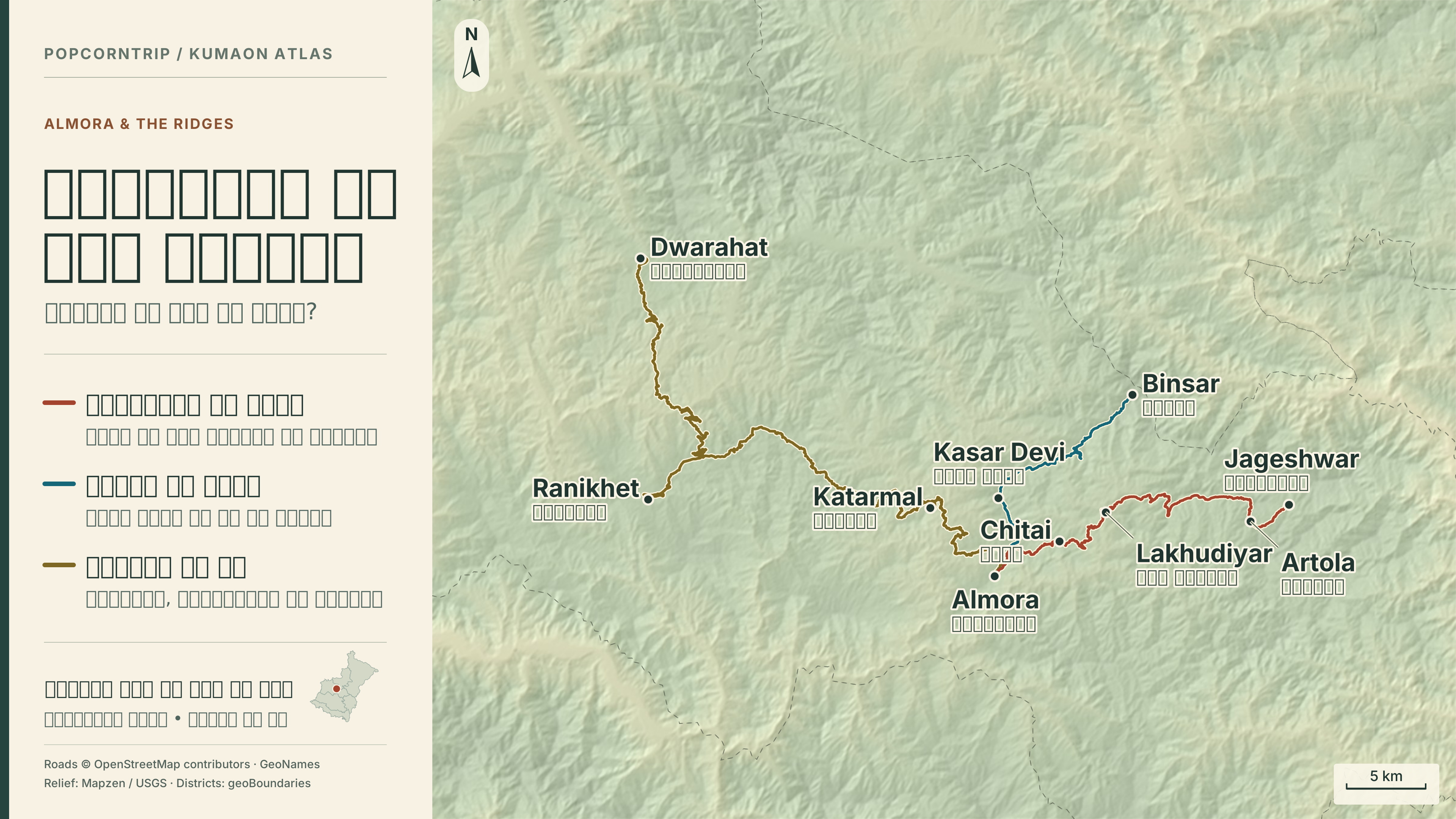
View map — Kausani, Baijnath and Bageshwar
Almora district guide · Baijnath temple group · PopcornTrip’s Almora–Pithoragarh journey · Almora city film · Kausani guide
Nine days towards Panchachuli
Give Munsyari two mornings. If the first one opens on cloud lodged in the valley, you still have another chance to see the peaks.
- Day 1 Travel from Kathgodam via Bhowali to Almora. Keep the evening for the bazaar. Sleep in Almora.
- Day 2 Drive from Almora via Someshwar to Kausani. Use the afternoon for a walk near the village or ashram. Sleep in Kausani.
- Day 3 Descend through Garur to Baijnath, then follow the Gomti to Bageshwar. By Bagnath temple the Gomti meets the Saryu. Sleep in Bageshwar.
- Day 4 Drive from Bageshwar via Kanda to Chaukori. Nearby Berinag is an optional outing if daylight and energy allow. Sleep in Chaukori.
- Day 5 Descend from Chaukori to Thal, then climb via Tejam and Birthi. Continue past the waterfall and Kalamuni to Munsyari. Set aside the day for the drive. Sleep in Munsyari.
- Day 6 Look for Panchachuli in the morning light, then walk near Nanda Devi temple or explore the town and its Johar heritage. Spend a second night in Munsyari.
- Day 7 Retrace the road via Kalamuni and Thal. Stop at one place you missed and sleep in Chaukori.
- Day 8 If the road is open, return to Almora via Berinag, Sheraghat and Dhaulchhina. Sleep in Almora.
- Day 9 Descend via Khairna and Bhowali to Kathgodam. If disruption looks likely, take an onward connection the morning after returning to the plains.
Add a day in Munsyari for the Khaliya Top trek after checking the trail. For Patal Bhuvaneshwar and Gangolihat, add a night at Chaukori and approach via Berinag. The cave has a narrow entrance.
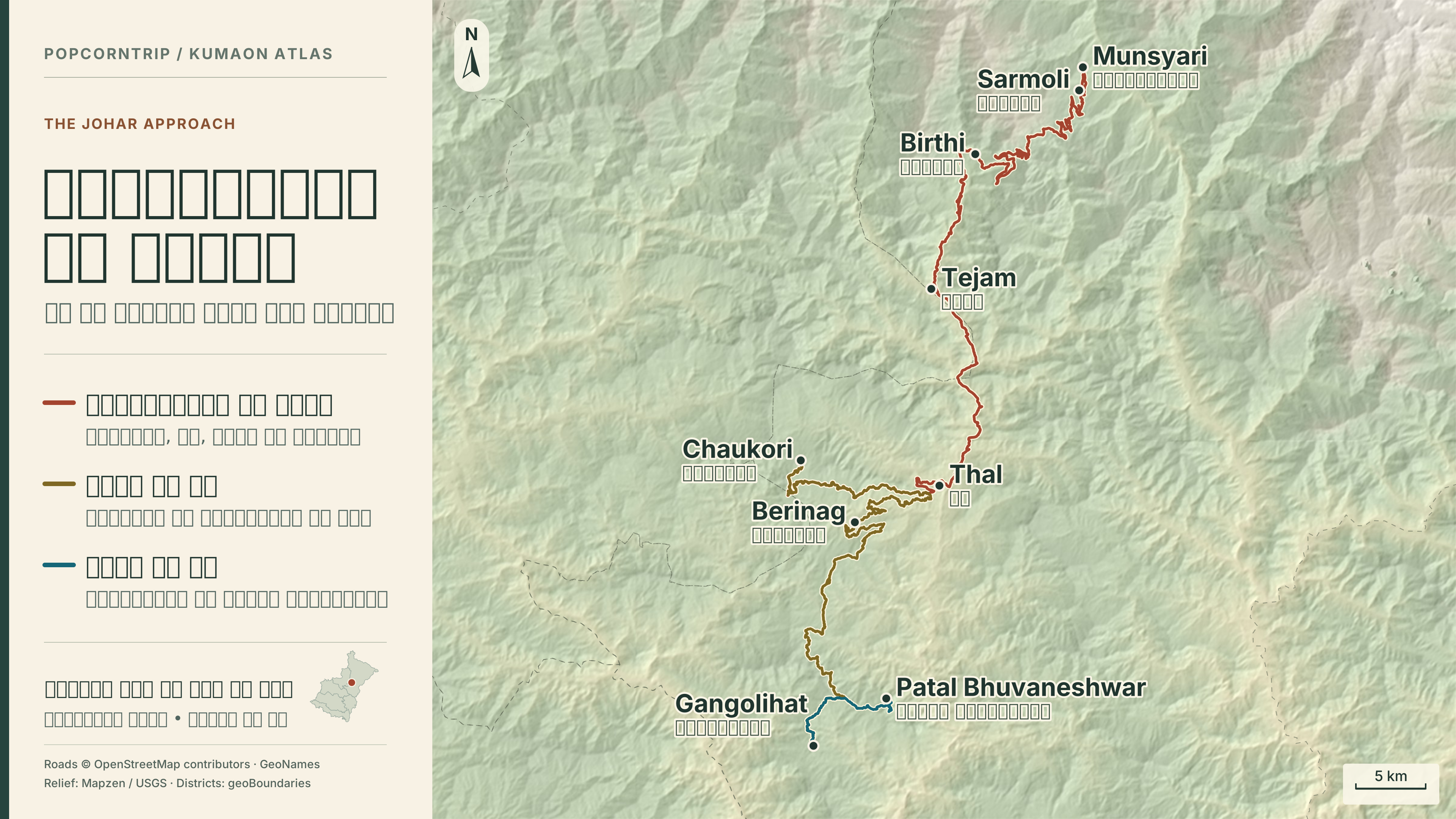
View map — Kausani, Baijnath and Bageshwar
Bageshwar district temples · Pithoragarh district excursions · Birthi and the glacier routes · Gangolihat and Patal Bhuvaneshwar · Munsyari guide · Munsyari stay directory
Five days from Champawat to the Soar valley
Enter Kumaon from the east for the carvings of Baleshwar and the hills around Lohaghat. Mayawati and Abbott Mount may look close on a map, but each has its own approach.
- Day 1 Ascend from Tanakpur to Champawat and allow time for the stone carvings at Baleshwar temple. Sleep in Champawat.
- Day 2 Go to Lohaghat and choose either Mayawati Ashram or Abbott Mount. Ask about visiting hours before going to the ashram. Sleep in Lohaghat.
- Day 3 Drive via Ghat towards Pithoragarh. In clear weather use some of the afternoon for the outlook towards the Soar valley from Chandak. Sleep in Pithoragarh.
- Day 4 Retrace the road via Lohaghat to Champawat. Take the market or temple walk you missed on arrival. Sleep in Champawat.
- Day 5 Descend to Tanakpur. For Nanakmatta Sahib, continue in the plains towards Khatima and arrange your onward journey to suit.
Give Purnagiri an additional day based in Tanakpur. For the confluence of the Kali and Saryu at Pancheshwar, keep a separate day from the Lohaghat area.
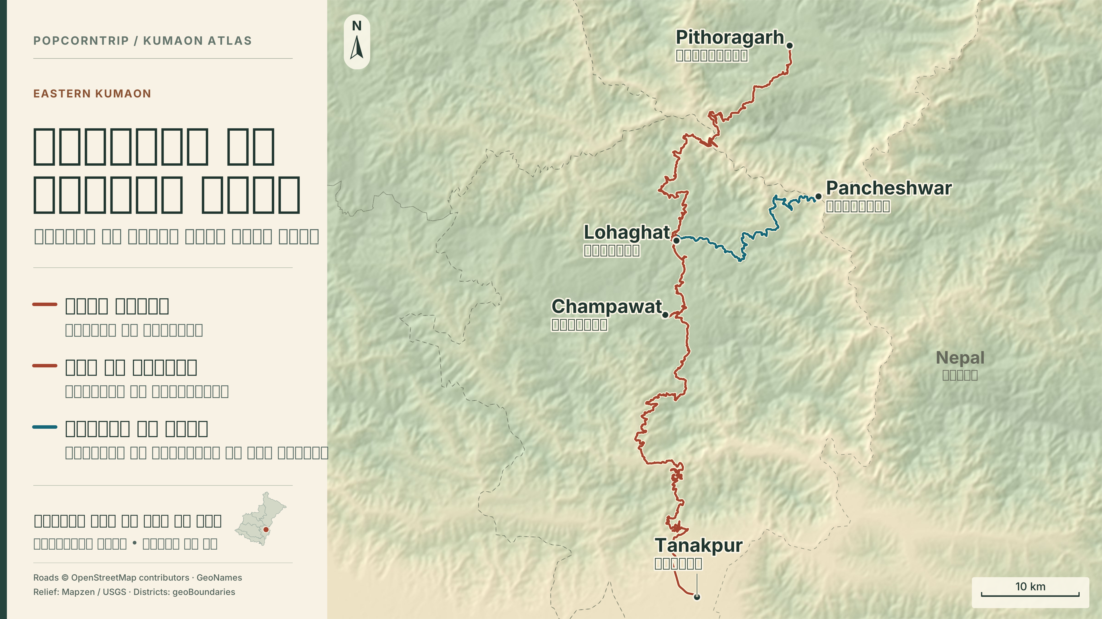
View map — The plains and gateways · View map — Pithoragarh and Dharchula
Champawat district guide · Pithoragarh district excursions · Udham Singh Nagar district guide · Chandak above Pithoragarh
From Bageshwar towards Pindari
The road towards Kapkot leads to the approaches for Pindari, Kafni and Sunderdhunga. On the Pindari trail beyond Khati, Dwali and Phurkia are successive halts. Ask a local guide where the road currently ends, where the walk begins and how many days to allow for the return. Plan meals and trail accommodation as a separate expedition.
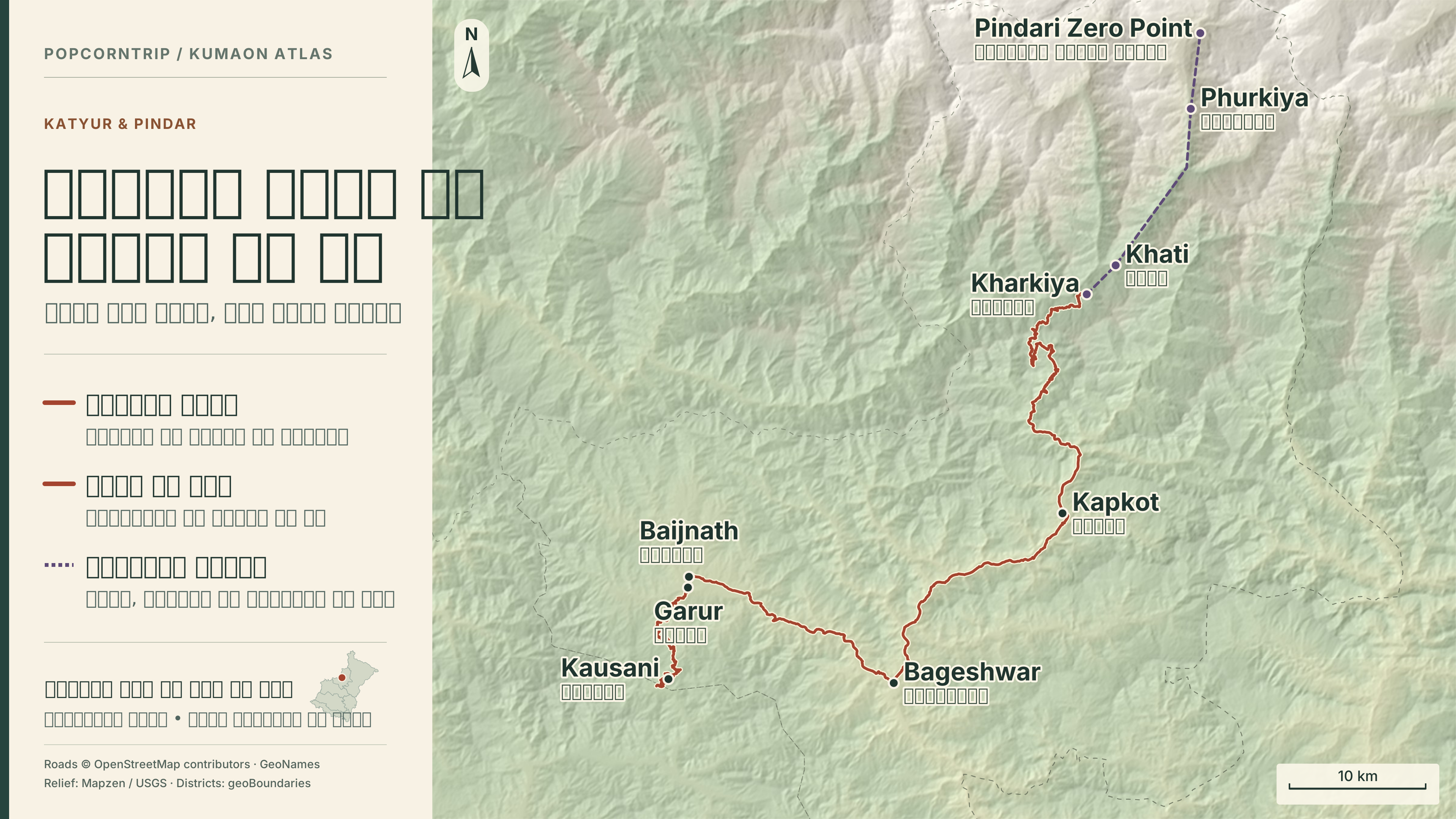
Pindari and Kafni approaches
Dharchula and the upper valleys
From Pithoragarh, travel via Jauljibi to Dharchula on the Kali. Beyond Tawaghat, Darma and Byas valleys lead in different directions. Panchachuli Base Camp in Darma and the Adi Kailash–Om Parvat journey each need a dedicated plan. Seeing Panchachuli from Munsyari is a third experience. Check current permission, identity documents, medical requirements and access for the chosen upper valley with the Dharchula administration or KMVN.
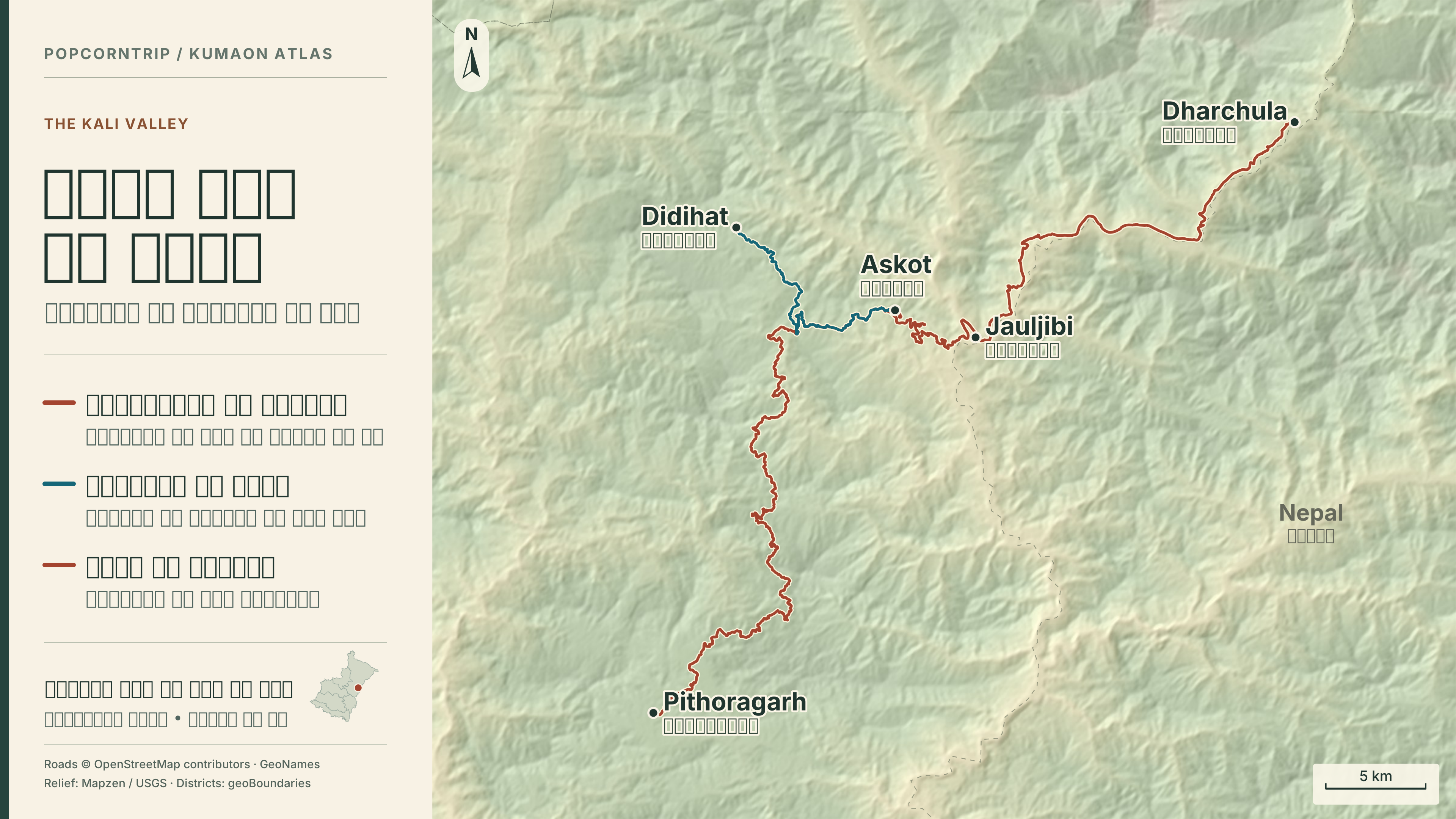
Pithoragarh district excursions · KMVN Adi Kailash itinerary and permit
Allow for weather and transport
The plans count arrival at the gateway as day one and the descent as the last day. Add travel to and from your home city separately. If using buses or shared taxis, confirm your next drop-off and last return service the evening before. Check the district forecast and road report before leaving in wet weather, and ask about snow on high sections such as Kalamuni in winter. When an upper road closes, keep the night in Chaukori or Almora and walk locally.
PWD road reports · IMD Dehradun weather warnings
Map credits and data
Roads © OpenStreetMap contributors (ODbL 1.0), routed with OSRM. Place points from GeoNames (CC BY 4.0) and OpenStreetMap. District boundaries from geoBoundaries, Spatial Data Pvt. Ltd. and the Local Government Directory (ODbL 1.0). Relief from Mapzen, the Linux Foundation, USGS and NOAA terrain data.
Download the offline guide, original SVG maps, source notes and GeoJSON (ZIP)
OpenStreetMap · ODbL 1.0 · GeoNames · geoBoundaries · Mapzen Terrain Tiles